Planting Weather Forecast: More Moisture Will Prolong Drying Over the Next Ten Days
The Planting Weather Forecast does not look that favorable over the next ten days in the east. Specifically, we are seeing four threats of rain between this weekend and early the week of May 6th, with no more than 2-3 days of dryness in-between each wave, sometimes only 1 day between waves. So, we will not see net drying over the next 10 days, and all of a sudden, we have a little bit of anxiety about planting. Longer term looks a bit better, but time will tell.
We start the weekend with scattered showers and storms lingering on Saturday morning after starting off Friday afternoon and overnight. The rain totals from that first wave of moisture will be .25”-.75” over about 70% of the state. We see action end Saturday afternoon and evening, and we should make it through most of Sunday with partly sunny and warm conditions. Precipitation returns late Sunday afternoon and evening and rolls through Monday afternoon. That second wave brings an additional .25”-.75” over 90% of Indiana. We get 36 hours of dry weather from Monday evening through Tuesday. Then Wednesday we start off May with scattered showers. Rain totals Wednesday will be .25”-.75” with 75% coverage.
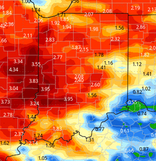
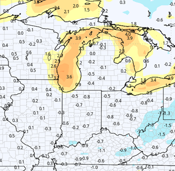
Dry weather for Thursday, Friday and Saturday. Thursday starts cool, but not as cold as this past week. Then temps moderate quickly to finish the week, and temps should be above normal. Evaporation rates will be good, near maximum, but we likely just run out of time for drying. Showers are back with a frontal boundary for Sunday the 5th. Rain potential looks to be up to half an inch again, with coverage at 80%. While those rain totals next week are not over the top, it does mean we are not drying on those rainy days, and we just can’t quite string together a dry trend that is long enough to produce widespread planting opportunities. The map below shows rain totals for the next 10 days.
Extended Period:
We start the following week dry on Monday the 6th. We keep the dry pattern through the 7th and 8th before a frontal boundary sags through the state for the afternoon of the 9th and early the 10th. Rain totals are not that impressive at a few hundredths to .3” with coverage at 60%. Dry, warm weather is back for the afternoon of the 10th, the 11th and 12th. So, that means in our extended window, we are starting to see some potential planting windows emerge, especially if the system late on the 9th can fizzle out and merely produce sprinkles or hit and miss coverage.
Weeks 3 & 4:
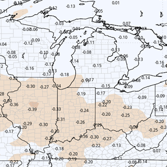
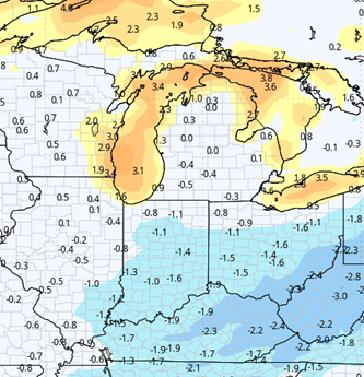
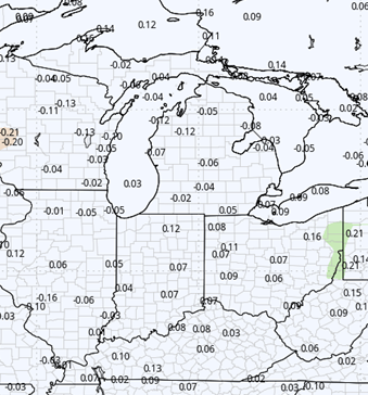
Precipitation looks to be below normal in week 3 and near normal for week 4. If that holds, any planting window that opens in the extended 11-16 day forecast window would be on track to hold into mid-May. Temps though will be below normal in week 3, returning to near normal in week 4.
Week 3 Precipitation (Green = above normal, Brown = below)
Week 3 Temperatures (yellow/orange = above normal, blue = below)
Week 4 Precipitation (Green = above normal, Brown = below)
Week 4 Temperatures (yellow/orange = above normal, blue = below)
“}]]